
Little Logan River at River Hollow Park
Point where the Logan River Watershed Project wants to pipe the river for irrigation
Courtesy & Copyright Hilary Shughart, Photographer
Please encourage your friends and associates who love the Logan rivers that surround The Island to show up at water district and city council meetings and let your voice be heard:
Save and Restore
The North Branch of the Logan River
a.k.a. The Little Logan River (LLR)
Contents:
-
- 2026 Logan River Watershed EIS (Environmental Impact Statement)
-
- NRCS Public Comment Meeting
-
- Written comments will be accepted for 45 days
-
- Download the Draft Environmental Impact Statement
-
- Flyer: Logan River Watershed Draft Plan-Environmental Impact Statement–Notice of Availability and Public Comment Meeting
-
- Our Analysis of the Logan River Watershed Draft Plan Environmental Impact Statement(EIS)
-
- Denial of Historic River Status
-
- Burr 1856 Survey with North Branch of the Logan River (Little Logan River) Highlighted
-
- Current BLM Utah Interactive Map with North Branch of the Logan River(LLR) highlighted
-
- Federal & US Army Corp of Engineers
-
- State
-
- Logan City
-
- Cache County
-
- Plats
-
- 5a. Confluence of the North Branch of the Logan River and the South Branch of the Logan River
-
- 5b. Martineau Map of Surveys on Logan Island
-
- 5c. Plat Map of Y east of Preston Ave: Logan-Hyde Park (Crockett Canal )
-
- Take Action: Submit your thoughts before June 22, 2026
-
- The Little Logan River is first and foremost the historic river upon which the City of Logan was founded
-
- Background
-
- The Proposal to Sever the Little Logan River from the Logan River
-
- EPA NEPA Comments on the proposed EIS
-
- A Historical Look at Logan Water Rights
-
- Timeline
-
- 1922 Kimball Decree
-
- Southwest Field Irrigation
-
- The Crockett Diversion
-
- History of Land Surveying in Cache County Storymap
-
- See also-Additional useful references
-
- 1856 Burr Survey
-
- Nathan Kimball Survey Map 1877
-
- Logan City Survey Map 1891
-
- Notes from Cartographer Gerald Hughes
-
- USGS Logan River Above State Dam, Near Logan, UT (Little Logan River)
-
- Look for “Little Logan River” References-Kimball Decree
-
- History of Land Surveying in Cache County (link)
-
- Updated Wetlands Mapping in Cache County
-
- U.S. Fish & Wildlife Service Wetlands Inventory
-
- Logan River Water Users Association Canal System
-
- USGS 1890 Map-Deltas formed in Lake Bonneville by the Logan River
-
- Cache County Township Plats, Page 59 of 107, 1880-1899
-
- 1967 Logan Parcel Map by Lynn N. Harris
-
- Cache County Parcel Viewer (Current)
-
- The History of a Valley: Cache Valley Utah-Idaho
-
- EPA Streams and Waterbodies in Utah, National Hydrography Dataset
-
- National Park Service Nationwide Rivers Inventory
-
- Mitigating Flood Risk: Replacing the Crockett Diversion Structure and Restoring the Logan River
-
- Trending today–Daylighting Piped Rivers and Streams:
-
- How ‘Daylighting’ Buried Waterways Is Revitalizing Cities Across America
-
- Stream Daylighting brings waterways above ground for all to enjoy
-
- Daylighting Salt Lake’s City Creek: An Urban River Unentombed
-
- Logan City Proposed River Setback Modifications
- Campaigns:
-
- 2024-2025 Petition to Save the Little Logan River
-
- Petition Text
-
- Petition Results
-
- 2026 Logan River Watershed EIS (Environmental Impact Statement)
Logan River Watershed EIS [(Environmental Impact Statement)]
Public Meeting May 20, [2026] Logan High School, 6-8 p.m
If you think the North Branch of the Logan River (Little Logan River) and the riverside public parks corridor are worthy of preservation, let the Logan River Watershed Project(LRWP) team know!
Public information meeting Wednesday 5/20, Logan High School, 6-8 p.m.
See food for thought below.***
PUBLIC NOTICE–DRAFT PLAN-EIS
Logan River Watershed, Cache County, Utah
The U.S. Department of Agriculture’s Natural Resources Conservation Service (NRCS), in cooperation with the Cache Water District, Logan City, North Logan City, Hyde Park City, and Crockett Avenue Irrigation Company as project Sponsors, announces the availability of the Logan River Watershed Draft Plan–Environmental Impact Statement (Draft Plan-EIS) prepared under the NRCS Watershed Protection and Flood Prevention Program (Public Law 83-566). NRCS will hold a public comment meeting:
Date: Wednesday, May 20, 2026
Time: 6:00-8:00 p.m. (MST)
Location: Logan High School (162 W. 100 S., Logan, Utah)
The meeting will begin with a brief presentation at 6:15 p.m., followed by opportunities to submit written comments and speak informally with the project team.
The Draft Plan-EIS evaluates alternatives for agricultural water management, flood prevention, and public recreation in the Logan River Watershed, including irrigation efficiency improvements, water conservation, instream flow preservation, flood risk reduction, and recreational enhancements. The Draft Plan-EIS is available: online: bit.ly/LoganRiverWatershedProject and a hard copy is also available at Cache County Executive Office 199 N. Main Street, Logan, Utah.
Written comments will be accepted for 45 days following publication of the Notice of Availability in the Federal Register (May 8–June 22, 2026). Comments may be submitted by:
Mail: Logan River Watershed Draft Plan-EIS
Attn: Ammon Boswell, Watershed Program Manager, USDA, NRCS
1950 West Main St., Tremonton, Utah 84337
Email: ammon.boswell@usda.gov (include “Logan River Draft Plan-EIS Comment” in the subject line).
For additional information, contact the Logan River Watershed Study Team at ammon.boswell@usda.gov.
#
***FOOD FOR THOUGHT:
1. Does the LRWP DEIS acknowledge that the North Branch of the Logan River (Little Logan River) is the north fork of the Logan River channel loop around the Logan Island, with the same Federal, State, and Local protections of a natural flowing stream as the main stem and the South Branch of the Logan River? (NO, it incorrectly assumes that the “Little Logan” River is just a canal!)
2. Does the LRWP acknowledge the right to year round flows of 72 cfs of nonconsumptive power water rights for Central Milling hydroelectric power generation. (NO, it says there are only irrigation season rights).
3. Does the LRWP DEIS acknowledge the recreational value of floating and fishing in the Little Logan River, joys which will not be sustained with a summer flow of 5 cfs “when water rights are available”? (NO: The drastic cut to flows in riverside parks is as follows:
River Hollow Park will drop from about 80 cfs to 5 cfs.
Jens Johansen from about 75 cfs to 5 cfs.
Merlin Olsen Central Park and the Fairgrounds will drop from about 10 cfs to 5 cfs, meaning even young children will no longer be able to float down the river!
The negative environmental and recreational impacts affect 13 public parks and recreation areas, including River Hollow Park, Jens Johansen Park, Merlin Olsen Central Park, Pioneer Park, Garff Wayside Gardens, Logan High School/Glen Worthington Memorial Park, Kilowatt Park, Cache County Fairgrounds, Zootah, Willow Park, Willow Park West, Majestic Park, and the Kunzler Conservation Easement.
Flyer: Logan River Watershed Draft Plan-Environmental Impact Statement–Notice of Availability and Public Comment Meeting
Our Analysis of the Logan River Watershed Draft Plan Environmental Impact Statement(EIS)
Denial of Historic River Status
Despite having been given ample documentation of the natural flowing stream status of the North Branch of the Logan River (Little Logan River), the Logan River Draft Plan EIS writers falsely claim that the “Little Logan” is an “EXCAVATED ARTIFICIAL DRAINAGE SYSTEM.” This current BLM Township and Range Map shows the same highlights of the river as seen on the 1856 Burr Survey, which identified the existence of the North Branch of the Logan River three years before the first white settlers arrived in 1859, and excavated the Logan Hyde Park Canal from the North Branch of the Logan River in 1860. Examine closely, the canal diversion is the Y near Preston Avenue, where the North channel is the canal going north to Canyon Road, and the south channel is the North Branch of the Logan River, heading to Merlin Olsen Central Park. This is shown on the Plat Map below.
Note that three years before the first white settlers arrived, the Burr Survey of 1856 shows the North Branch of the Logan River in Sections 33 & 34 of the Township and Range Msp T12 N – R1E:
The river bisects the bottom left quadrant of Section 34, from the northeast corner to the southwest corner, then crossing the southeast edge of Section 33.
The highlighted reach of the river on the Burr Survey corresponds today to Jens Johansen Park through Central Park, Pioneer Park, Garff Wayside Gardens, Mill Creek Apartments, to Logan High School.
The first major canal, the Logan Hyde Park, was excavated from the banks of the North Branch of the Logan River, up onto the Canyon Road bluff, then down to Central Milling, Pioneer Park, and north around 170 E Center Street ( east side of Anniversary Inn).
Burr 1856 Survey with North Branch of the Logan River (Little Logan River) Highlighted
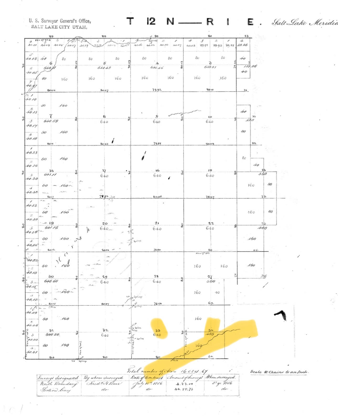
The Burr Survey of 1856, the North Branch of the Logan River can be seen in Sections 33 & 34 of the Township and Range Map T12 N – R1E
Highlighted by Hilary Shughart
Current BLM Utah Interactive Map with North Branch of the Logan River (Little Logan River) Highlighted
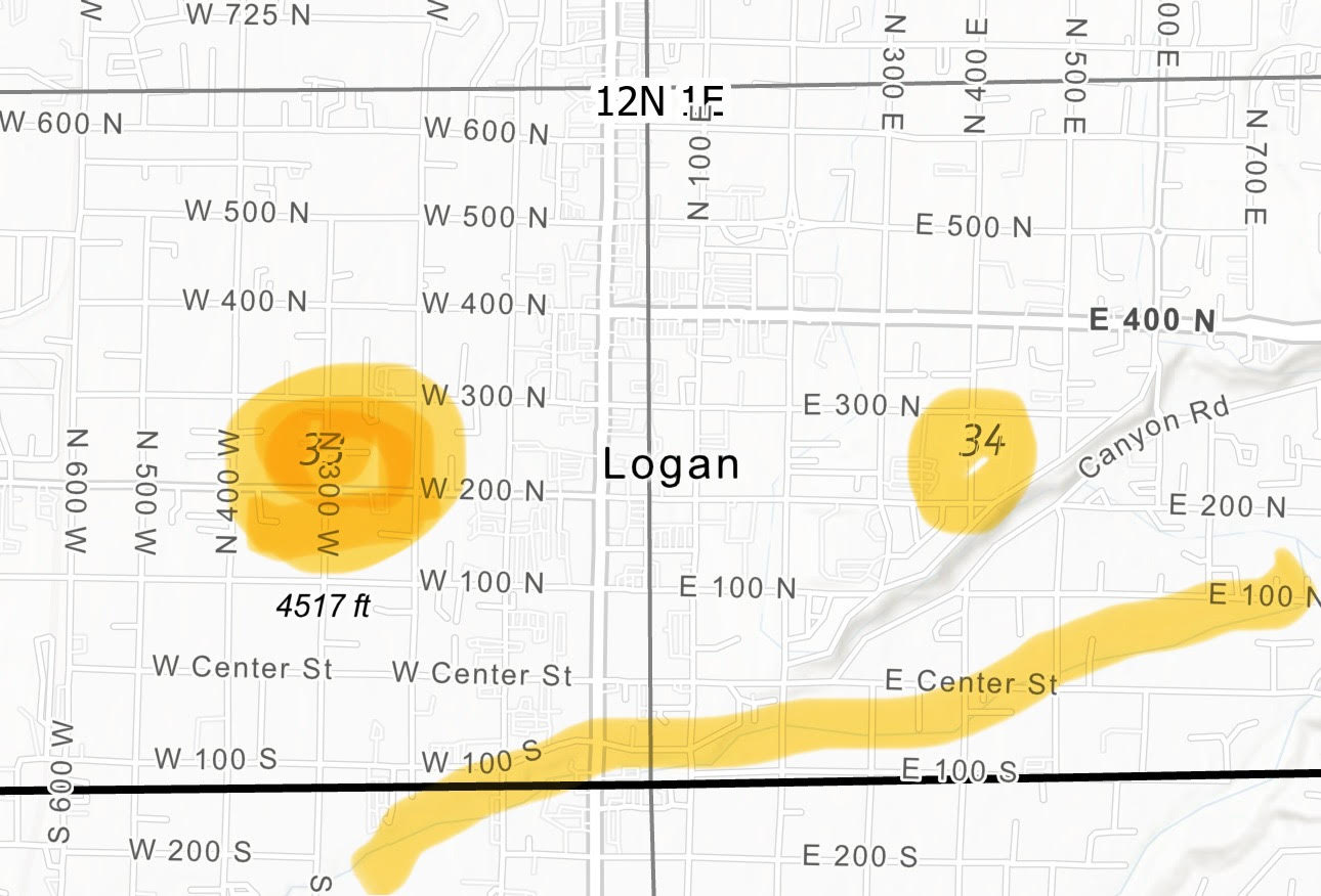
Screenshot of current BLM Utah Interactive Map
Showing the North Branch of the Logan River with canals tapped therefrom.
Note the river from the 1856 Burr Survey continues to exist.
Highlighted by Hilary Shughart
The North Branch of the Logan River
Known as the Little Logan River, this public parks corridor forks from the Logan River at River Hollow Park, conveys irrigation water to ten canals, flows through 13 public parks and recreation areas, including River Hollow Park, Jens Johansen Park, Merlin Olsen Central Park, Pioneer Park, Garff Wayside Gardens, Logan High School/Worthington Park, Kilowatt Park, Cache County Fairgrounds, Zootah, Willow Park, Willow Park West, Majestic Park, and the Kunzler Conservation Easement, where it rejoins the Logan River on the Western edge of the City. It is popular amongst residents during the summer months for tubing, swimming, wading, and other water-based activities. In addition to its recreational benefits, the Little Logan is used to cool the Eccles Theater in Downtown Logan.
Herewith Federal, State, Logan City, and Cache County documentation of the fact that the North Branch of the Logan River is a natural flowing stream:
1. FEDERAL
a) The Little Logan River is a registered geoname, and listed as a stream on the USGS Geographic Names Information System. [1]
b) Burr Survey of 1856, before the first white settlers arrived to found Logan in 1857, and while Utah was still a Territory. Shows the North Branch of the Logan River
c) U.S.Army Corps of Engineers (USACE)
“The Little Logan River is a disturbed, re-routed perennial channel.”
Completion Date of Approved Jurisdictional Determination (AJD):July 9, 2021.
ORM Number: SPK-2020-00588.
https://www.spk.usace.army.mil/Portals/12/documents/regulatory/jd/2021/2021-07/SPK-2020-00588-AR-ApprvdJDForm-NWPR.pdf
2. STATE:
A) Administrative Rule R655-13
(11) Natural stream: Any waterway, along with its fluvial system, that receives sufficient water to sustain an ecosystem that distinguishes it from the surrounding upland environment.
(B) Title 23A Wildlife Resources Act; 23A-1-101. Definitions.
(a)”Natural flowing stream” means a topographic low where water collects and perennially or intermittently flows with a perceptible current in a channel formed exclusively by forces of nature.
b)”Natural flowing stream” includes perennial or intermittent water flows in a:
(i)realigned or modified channel that replaces the historic, natural flowing stream channel
C) Chapter 29 Public Waters Access Act Part 1 General Provisions:
(A) within a natural or realigned channel;
(9) (a) “Recreational access” means to use a public water and to touch a public access area incidental to the use of the public water for:
(i) floating;
(ii) fishing; or
3. LOGAN CITY:
A) Ordinance 25-11: Critical Lands Overlay Zone, Logan Land Development Code 17.24.010, B. Riparian Areas …”North Branch of Logan River (Little Logan River)”. The Logan River system and the North Branch of the Logan River (Little Logan River) are cited in the Logan General Plan 2045. [3]
B) Logan General Plan 2045
North Branch Logan River (page 108)
GOALS, page 27: Natural Environment, Parks, and Open Space
Goal: Support equitable recreational access to public parks, trails, recreational facilities, open spaces, nearby mountains, and the Logan River system.
Goal: Promote a sustainable Logan that accommodates growth and economic development while protecting and enhancing the City’s natural assets and the functions of its ecological systems.
4. CACHE COUNTY:
a) DEED to the River Bed of the North Branch of Logan River. [4]
b) PLAT MAPS. [5]
c) LEGAL PROPERTY DESCRIPTIONS
References:
[1] FEDERAL:
Little Logan River is a registered geoname here https://www.geonames.org/5777431/little-logan-river.html
and it’s also listed as a stream on the USGS Geographic Names Information System. https://www.usgs.gov/us-board-on-geographic-names/domestic-names Click on details once you find it.
[2] STATE:
Administrative Rule R655-13 was implemented in 2004 and was intended to add clarification to Section 73-3-29 of the Utah Code. Among other things, R655-13 establishes the State Engineer’s permitting jurisdiction, defines a natural stream, and gives requirements for some specific stream alteration activities.
(11) Natural stream: Any waterway, along with its fluvial system, that receives sufficient water to sustain an ecosystem that distinguishes it from the surrounding upland environment.
B) Title 23A Wildlife Resources Act; 23A-1-101. Definitions.
(27)
(a)”Natural flowing stream” means a topographic low where water collects and perennially or intermittently flows with a perceptible current in a channel formed exclusively by forces of nature.
(b)”Natural flowing stream” includes perennial or intermittent water flows in a:
(i)realigned or modified channel that replaces the historic, natural flowing stream channel;and
(ii)dredged natural flowing stream channel.
(c)”Natural flowing stream” does not include a human-made ditch, canal, pipeline, or other water delivery system that diverts and conveys water to an approved place of use pursuant to a certificated water right.
Title 23A Wildlife Resources Act; 23A-1-101. Definitions.
https://le.utah.gov/xcode/Title23A/Chapter1/23A-1-S101.html?v=C23A-1-S101_2025070120250507
Chapter 29 Public Waters Access Act Part 1 General Provisions:
(8) (a) “Public water” means water:
(i) described in Section 73-1-1; and
(ii) flowing or collecting on the surface:
(A) within a natural or realigned channel; or
(B) in a natural lake, pond, or reservoir on a natural or realigned channel.
(b) “Public water” does not include water flowing or collecting:
(i) on impounded wetland;
(ii) on a migratory bird production area, as defined in Section 23A-13-101;
(iii) on private property in a manmade:
(A) irrigation canal;
(B) irrigation ditch; or
(C) impoundment or reservoir constructed outside of a natural or realigned channel; or
(iv) on a jurisdictional wetland described in 33 C.F.R. 328.3.
(9) (a) “Recreational access” means to use a public water and to touch a public access area incidental to the use of the public water for:
(i) floating;
(ii) fishing; or
(iii) waterfowl hunting conducted:
(A) in compliance with applicable law or rule, including Sections 23A-5-314, 73-29-203, and 76-11-209; and
(B) so that the individual who engages in the waterfowl hunting shoots a firearm only while within a public access area and no closer than 600 feet of any dwelling.
(b) “Recreational access” does not include:
(i) hunting, except as provided in Subsection (9)(a)(iii);
(ii) wading without engaging in activity described in Subsection (9)(a); or
(iii) any other activity.
Chapter 29 Public Waters Access Act Part 1 General Provisions
73-29-102 Definitions.
https://le.utah.gov/xcode/Title73/Chapter29/C73-29_1800010118000101.pdf
[3] LOGAN:
Ordinance 25-11: Critical Lands Overlay Zone,
Logan Land Development Code
17.24.010, B. Riparian Areas …”North Branch of Logan River (Little Logan River)”
https://cms9files.revize.com/loganut/departments/admin/council/25-11%20Critical%20Lands%20Overlay%20Zone%20Riparian%20Areas.pdf
GOALS, page 27: Natural Environment, Parks, and Open Space
Goal: Support equitable recreational access to public parks, trails, recreational facilities, open spaces, nearby mountains, and the Logan River system.
Goal: Promote a sustainable Logan that accommodates growth and economic development while protecting and enhancing the City’s natural assets and the functions of its ecological systems.
Logan General Plan 2045
https://cms9files.revize.com/loganut/departments/comdev/General%20Plan%202026/ADOPTED_Logan%20UT%20General%20Plan_MQ.pdf?t=20260518112315612&t=20260518112315612
Logan General Plan 2045, SEE: North Branch Logan River (page 108)
[4] [1]”townsite deed from the mayor of Logan city who received the patent from the United States for the land that covers the city of Logan. In this townsite deed which is recorded in Book B Pages 538-544 there is a description in which deeded the bed of the North Branch of the Logan River (The Little Logan River) to the corporation of Logan City. This deed was recorded April 20th of 1894 in our office. ”
The River Bed of South Branch of Logan River in Section three 3 Township eleven (11) north of Range one (1) east containing more or less five (5) acres and eighty (80) rods.
The River Bed of North Branch of Logan River is in Sections thirty three (33) and thirty four (34) pTownship Twelve (12) north of Range one (1) East containing more or less Eleven (11) acres and
[5] Plat Maps
5a. Confluence of the North Branch of the Logan River and the South Branch of the Logan River into the Logan River
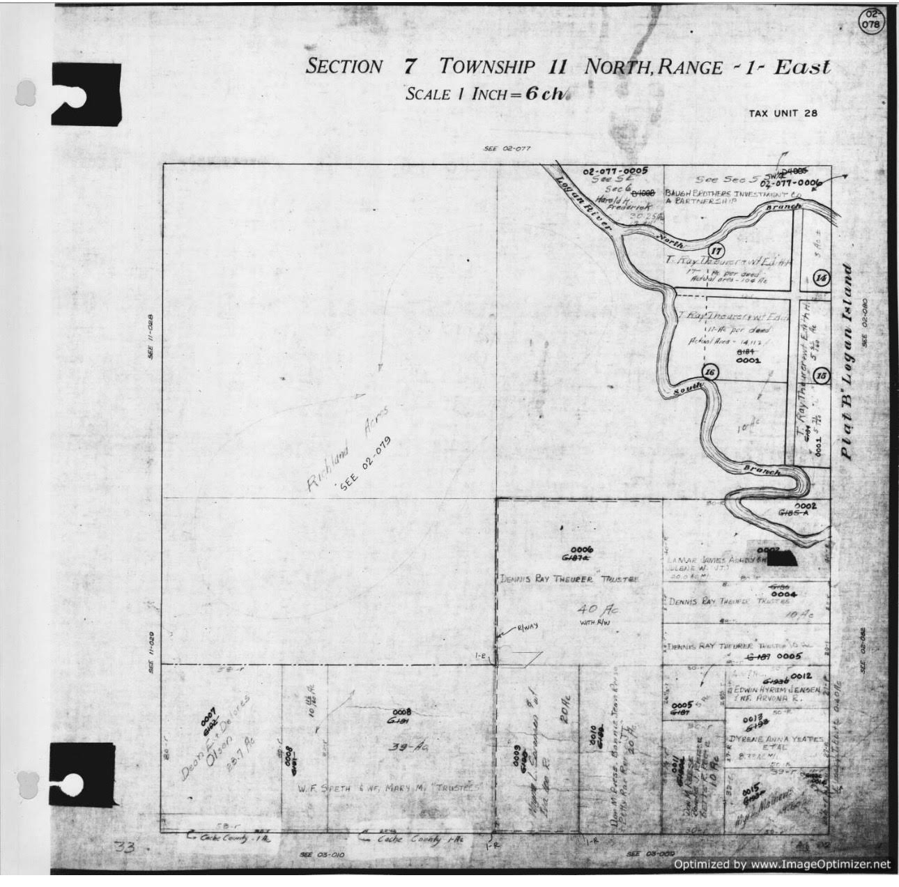
Confluence of the North Branch of the Logan River and the South Branch of the Logan River into the Logan River
1978 Plat Map, Parcel ID: 02-345-0058
Courtesy Cache County GIS
1978 Plat Map, Parcel ID: 02-345-0058
https://gis.cachecounty.gov/PlatMaps1978/Book_2/02-078.jpg
5b. Map of Surveys on Logan Island , Title: Logan Island, Utah Plats B, C, D , Citation: Martineau, J.H. (1860-1896).
https://libraryusu.access.preservica.com/uncategorized/IO_1aba6720-aa09-4daf-ab9f-e2075cf841b0/
5c. Plat Map of Y east of Preston Ave
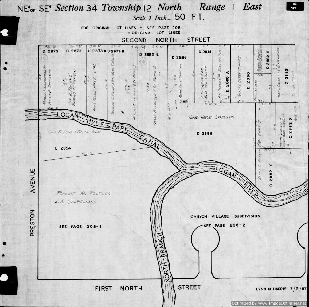
Plat Map of Y east of Preston Ave: Logan-Hyde Park (Crockett Canal ) is the north fork, and the south fork is the North Branch of the Logan River
Courtesy Cache County GIS
Plat Map of Y east of Preston Ave: Logan-Hyde Park (Crockett Canal ) is the north fork, and the south fork is the North Branch of the Logan River (Little Logan Canal).
https://gis.cachecounty.gov/PlatMaps1970/Book_6/06-080.jpg
|
Take Action: Submit your thoughts before June 22, 2026 Download the Logan River Draft Plan Environmental Impact Statement and let the NRCS and their contractors know your thoughts. Written comments will be accepted for 45 days following publication of the Notice of Availability in the Federal Register (May 8–June 22, 2026). Comments may be submitted by: Mail: Logan River Watershed Draft Plan-EIS Email: ammon.boswell@usda.gov (include “Logan River Draft Plan-EIS Comment” in the subject line). For additional information, contact the Logan River Watershed Study Team at ammon.boswell@usda.gov. |
The Little Logan River is first and foremost the historic river upon which the City of Logan was founded
The North Branch of the Logan River, known as the Little Logan River is part of the natural Logan River channel loop around the Logan Island. The Logan Hyde Park Canal was the first major local canal, and it was excavated from the banks of this river, creating the “Y” near Preston Avenue, where the canal heads northwesterly across Canyon Road and then southwesterly to the Central Milling penstock, the Logan Hyde Park Canal, and the Crockett Canal, which flows along the east side of the Pioneer Place Apartments, and back into the river channel. The south fork of the “Y” flows southwesterly to Merlin Olsen Central Park and on through Pioneer Park Garff Wayside Gardens, Mill Creek Apartments, Logan High School, the Cache County Fairgrounds, Zootah, Majestic Park, and the Kunzler Conservation Easement before the confluence with the South Branch back into the Logan River at the west edge of town.
- It is a river which feeds the Crockett Canals:
- The 1856 survey of Cache County shows only the North Branch of the Logan River. This was three years before the City of Logan was founded on the banks of the North Branch of the Logan River, ten years before the City of Logan was incorporated.
- The U.S. Geological Survey shows the Little Logan River as a river, and the canals it feeds as canals.
- Plat maps show the North Branch of the Logan River (LLR).
- Property titles list the North Branch of the Logan River (LLR).
- The canals have been excavated from the banks of the river – there is no overlap.
- The Crockett Canal is not on the list of major canals 1856-1956, but it does list the canals excavated from the banks of the river, including Logan Hyde Park, Logan Northfield, Logan Northwest Field (formerly Logan & Benson).
See: The History of a Valley: Cache Valley Utah-Idaho, Cache Valley Centennial Commission, 1856. - The Crockett Diversion weir in the Logan River was added about half a century after the canals were excavated from the banks of the North Branch of the Logan River.
- It is not a canal:
- A canal is man-made. The Little Logan River is an historic natural river channel.
- A canal has a diversion point. The Crockett Canal has no diversion point with the Utah Division of Water Rights. It is a distribution company which manages the water rights for ten canal companies.
- A canal has water rights. The Crockett Canal has no water rights.
- A canal has a service area. The Crockett Canal has no service area.
- The Kimball Decree (1922) lists the canal companies organized under the Crockett Avenue Irrigation & Distribution System, but does not list a Crockett Canal.
- The Cache County ArcGIS Canal Maps recognize the dual function of the “Crockett Canal/North Branch of Logan River”
Save and Restore the North Branch of the Logan River (Little Logan River-LLR)
Background:
The proposal to sever the Little Logan River from the Logan River
As currently proposed, the Crockett Avenue Distribution Company Pipeline will be enclosed in the riverbed of the Little Logan River (LLR) at River Hollow Park:
The main stem of the Little Logan River will be dried out all along the south bank of River Hollow Park, forever cutting off the Little Logan River from the Logan River.
The Little Logan River Greenbelt of parks will be dependent upon the release of piped and pressurized secondary water West of Crockett Avenue, with no water East of Crockett Avenue, no water for River Hollow Park.
There will be no more wading and tubing at River Hollow Park.
The historic Little Logan River will never again receive the very snowmelt which inspired the first white settlers to establish the City of Logan, and to farm the fertile Island between the Logan River and the Little Logan River.
Logan River Watershed Project, Natural Resources Conservation Service (US NRCS), US Department of Agriculture, https://www.nrcs.usda.gov/conservation-basics/natural-resource-concerns/watersheds/logan-river-watershed-project
We submit that the Little Logan River is a river, that the management of the water course is the duty of the City of Logan, not of the canal company, and that the tri-city secondary water Ag to Lawns Project has not been required to apply for a change of use permit. Thus, the State Engineer’s process for the Division of Water Rights has failed to evaluate for “the highest beneficial use,” and find the in-stream flows of the Logan River and the Little Logan River for environmental and recreational benefits as the highest beneficial use above and beyond lawns and ski lakes (The Willow Lakes wake lane alone has a surface area of 25 acres, is 20′ deep, and relies upon Logan culinary water). How can we be sacrificing the historic Little Logan River with the Ag to Lawns project right on the heels of establishing the Willow Ski Lakes projects? Why not work with the Division of Wildlife Resources on the need and the ability to lease or sell Crockett Water Rights for in-stream flows for the Logan River System, including the historic North Branch of the Logan River known as the Little Logan River, which is a tremendous recreational resource and wildlife habitat corridor from River Hollow Park to the confluence with the Logan River downstream from Trapper Park?
The 1922 Kimball Decree assigns most of the Crockett canal water from the Logan River at a location near River Hollow Park. One example is water for the Southwest Field Irrigation Company. See page 49 https://bearrivercommission.org/docs/Kimball%20Decree.pdf#page=49
235. Southwest Field Irrigation Co.
(a) 1860-May 1 11 c.f.s. [[[[Note: this reference to the Logan River is in fact the Little Logan River, referenced here as “part of the Logan River”- it is all one river system with a north and south branch that reunite at the west edge of Logan – i.e. the entire Little Logan River is within the municipal boundaries of the City of Logan, which is refusing to acknowledge this river, stating that instead that it is a canal, which is no more true than the main stem of the Logan River is a canal due to the fact that it has three dams and feeds the major Highline diversion about a mile and a half up Logan Canyon]]]Said Water to be diverted from Logan River at a point 600 feet Southeasterly from the Southeast corner of Block 6, Plat 4, Park Addition, Logan City Survey, and used for the irrigation of 880 acres of land in the West half of Sections 4 and 5, Town- ship 11 North, Range 1 East, S. L. M
(b) 1865-May 1 1 c.f.s.
Said water to be diverted from North branch of Little Logan River, a part of Logan River at a point near what is known as the South Slough and used for the supplemental irrigation of the lands last above described.
On the ArcGIS Canal Maps it is clear that the Southwest Field Irr. Co water is from the Little Logan River, which the Kimball Decree describes as the Logan River. The real challenge is getting Logan City to acknowledge their responsibility for the management of the Little Logan River(LLR) riparian area. River corridor protections apply for the North Branch of the Logan River just as for the South Branch. However, for unknown reasons, the City will not acknowledge the [smaller northern] river, and it is imperiled by the Logan River Watershed Project(LRWP)/The Langdon Group a.k.a. J-U-B ENGINEERS, Inc.(JUB) consideration of potential piping of the river, lining of the natural river channel, placing a pumphouse and paved trail within the natural river channel, and diversion of the perennial flows.
We contend that the waters of the Little Logan River were incorrectly asserted to be under the control of the several canal companies, the Crockett Canal Company speaking for most. Thus, the waters of the Little Logan River were errantly controlled at the diversion point shown above. Waters in the the Little Bear River should continue to flow during non-irrigation periods to allow replenishment of the ground water and nurturing of the trees and wildlife both in and along the river.

Crockett Diversion used to ensure water can be fed to canals from the Little Logan River
Courtesy USGS
https://storymaps.arcgis.com/stories/4c022c3979344da5b01f6c52893b7a11
Crockett Diversion
“The Crockett Diversion was originally constructed in the early 1900’s and is named after Alvin Crockett, Logan City’s first mayor. Originally built to support agriculture, the structure diverts water from the Logan River to the Little Logan River to ensure the delivery of the water rights established in the Kimball Decree. Today, the approximately 15,000 acres that can be irrigated by the Crockett Diversion’s waters include residential and commercial developments, parks, and agriculture fields. Crops irrigated by the Crockett Diversion’s waters include; corn, oats, alfalfa, hay, barley, wheat, and residential gardens. The Crockett Canal can safely pass 125 cubic feet per second of water. Cubic feet per second is a commonly used term to measure the flow of a stream and [one cfs] is equivalent to 7.5 gallons passing by every second.”
USGS Logan Floodplains Storymaps–Crockett Diversion: Map shows the Little Logan River from the source at River Hollow Park to the confluence west of Willow Lakes Subdivision and downstream from Trapper Park. https://storymaps.arcgis.com/stories/4c022c3979344da5b01f6c52893b7a11

The Little Logan River and the Logan River from USGS https://apps.nationalmap.gov/viewer/
The following three annotated USGS maps show both the Logan River and the upper Little Logan River on USGS maps. These rivers define the Island district where Logan was originally founded. Annotations show where canals pull water from the Little Logan River. https://apps.nationalmap.gov/viewer/

Northfield canal diverts from Little Logan River (North Branch of Logan River)
North bend of canal near possible site of pump house
Annotated USGS Maps showing the Little Logan River, as a free-flowing river, feeding a canal
Courtesy USGS & Hilary Shughart

Northfield canal diverts from Little Logan River (North Branch of Logan River)
North bend of canal near possible site of pump house
Annotated USGS Maps showing the Little Logan River, as a free-flowing river, feeding a canal
Courtesy USGS & Hilary Shughart

Northfield canal diverts from Little Logan River (North Branch of Logan River)
North bend of canal near possible site of pump house
Annotated USGS Maps showing the Little Logan River, as a free-flowing river, feeding a canal
Courtesy USGS & Hilary Shughart
LRWP Environmental Impact Statement(EIS) Notice of Intent (NOI) Public Comments: EPA NEPA Division
Comments from the EPA NEPA Denver office: “Our comments are focused on the following topics: purpose and need; range of alternatives; surface and groundwater resources; direct, indirect and cumulative effects; the Great Salt Lake; wildlife impacts; air resources; and climate change.” https://bridgerlandaudubon.org/wp-content/uploads/2024/08/25-official-comments-from-LRWP-april-2021.pdf
A Historical Look at Logan Water Rights
A Timeline: Logan Water Rights — A Work in Progress
-
- Logan Utah Water Rights Timeline
-
- Pre-settlement Cache County, located in the northern part of the state, is bordered by the Wasatch Mountains on the east and a spur of the Wasatch, the Wellsville Mountains, on the west. The Bear River flows through the northwestern corner of the county where the Little Bear, Blacksmith Fork, and Logan rivers add their waters to it. Cache County was formed in 1856 by the territorial legislature and its boundaries were redefined in 1864 when part of Cache became Richland (Rich) County.Northern Utah was part of the Plains Culture area and, later, Shoshoni territory. Between 1824 and 1855 Cache Valley was repeatedly visited by trappers and explorers. Among the early trappers in the area were James Weber and Jim Bridger in 1824 and Peter Skene Ogden and James Beckwourth in 1825. 1
-
- 1859 Settlement On 6 June 1859 a small group of Mormon settlers sent to Cache Valley by Brigham Young surveyed a fort site near the banks of the Logan River and began harvesting logs for houses. By the middle of the month, the first drawing for parcels of land took place. A second group plowed land and planted three acres of wheat on 10 June on an area called “the island.” 2
-
- 1859 Water-powered Industry built along the Little Logan River “Though not the first white settlement in Cache Valley, Logan became the principal city because of its central location and its abundant water supply for mills and irrigation.” 2 3
-
- 1860 Logan-Hyde Park Canal Created3
-
- 1864 Logan Northern Canal Created3
-
- 1864 Logan North Field Canal Created3
-
- 1864 Logan Northwest Field Canal Created3
-
- 1864 Logan Providence Canal Created (South Branch Logan River)3 “The builders only possessed crude tools and equipment, and some steep and rocky routes made the use of oxen and draft animals impossible. Consequently, errors were made—a canal out of the Logan River’south side intended for use east of River Heights and Providence ran uphill, and it took nearly two decades to completely re-do the canal and get the water running downhill.” 6 p59
-
- 1865 Logan Richmond Canal Created5
-
- 1881 Logan, Hyde Park & Smithfield Canal Created3
-
- 1896 Utah Statehood, January 4
-
- 1904-1973 Electricity generated at the mouth of Logan Canyon reduces the need for Water-Powered Industry
-
- 1912 Hydrographic Study 4 p81
-
- Barber-Swendsen Report 4 p74
-
- 1906 The Logan River Water Users’ Association formed 4 p80
-
- The Call Decree 4 p86
-
- 1922 The Kimball Decree 4 p95
“Earlier, in 1921, Cache County irrigators and Utah Power and Light Company went to court over control of the tributary streams to the Bear River. The resulting Kimball Decree of 1922 set the basic tenets pertaining to water rights throughout the county.” 6 p327 - 1922 The Kimball Decree 4 p95
-
- 1926 Amended Decree 4 p99
-
- Apr 2, 1961 Commissioner Appointed by the State Engineer to enforce division per water rights 4 p
-
- 1963 Amended Decree- Judgement in Logan City vs Water Users and subsequent agreement to supplement water users from city wells 4 p126
-
- 1960-Present Canal Companies consolidate and change as cities develop and croplands are changed to homes and gardens.
-
- 1973 Central Milling switches from water to electric power
-
- Crockett Diversion restricts annual flow from the Logan River
-
- 2024 Proposed piping of the waters of the Little Logan River for pressurized irrigation at the Crockett Diversion.
We propose that the Little Logan River should be allowed to naturally flow through the city and be pumped for pressurized irrigation on the west side of Logan.- May 8-June 22, 2026 Logan River Draft Plan Environmental Impact Statement (EIS)
- 2024 Proposed piping of the waters of the Little Logan River for pressurized irrigation at the Crockett Diversion.
- Timeline Credits:
- 1 Thatcher, Linda, Cache County, Utah History Encyclopedia, (University of Utah Press), https://www.uen.org/utah_history_encyclopedia/c/CACHE_COUNTY.shtml
2 Audrey M. Godfrey, History to Go, Utah History Encyclopedia, 1994, https://historytogo.utah.gov/logan/
3 Major Irrigation Canals Constructed in Cache Valley, Sons of the Utah Pioneers, Temple Fork Chapter, Marker 184, https://wchsutah.org/miscellaneous/markers4.pdf#page=91
See also Barlow, Jacob, Major Irrigation Canals Constructed in Cache Valley, https://jacobbarlow.com/2022/12/08/major-irrigation-canals-constructed-in-cache-valley/
4 Haws, Frank, A Critical Analysis of Water Rights and Institutional Factors and their Effect on the Development of Logan River, Theses and Dissertations, Utah State University, 1965,
https://digital.lib.usu.edu/digital/collection/Bear/id/6305/rec/85
5 Local History Timeline, Logan City Library, https://library.loganutah.gov/research___learn/local_history_timeline.php
6 Peterson, F. Ross, A History of Cache County Utah, Utah State Historical Society, Cache County Council, 1997, http://www.riversimulator.org/Resources/History/UtahCounties/HistoryOfCacheCounty1996Peterson.pdf
7 Culberson, James S., “The Functional and Aesthetic Uses of Two Cache Valley, Utah, Canals” (1975). All Graduate Theses and Dissertations. 2102.
https://digitalcommons.usu.edu/etd/2102
Burr Survey
First survey done by Frederick H. Burr in the summer of 1856 and submitted to the Surveyor General of Utah David H. Burr in the fall of 1856. In the History of Land Surveying in Cache County Storymap:
https://storymaps.arcgis.com/stories/76d1d5d4c52c44efac0df9df2f3ad07b
The following, very faint, three pages in TIFF format provided Courtesy Cherie Davis, Cache County GIS
They include the Township 11 North, Range 1 East and 12 North, Range 1 East surveys by Frederick H Burr and accepted by his father David H Burr, the Surveyor General of Utah.
The third is an 1877 Nathan Kimball survey
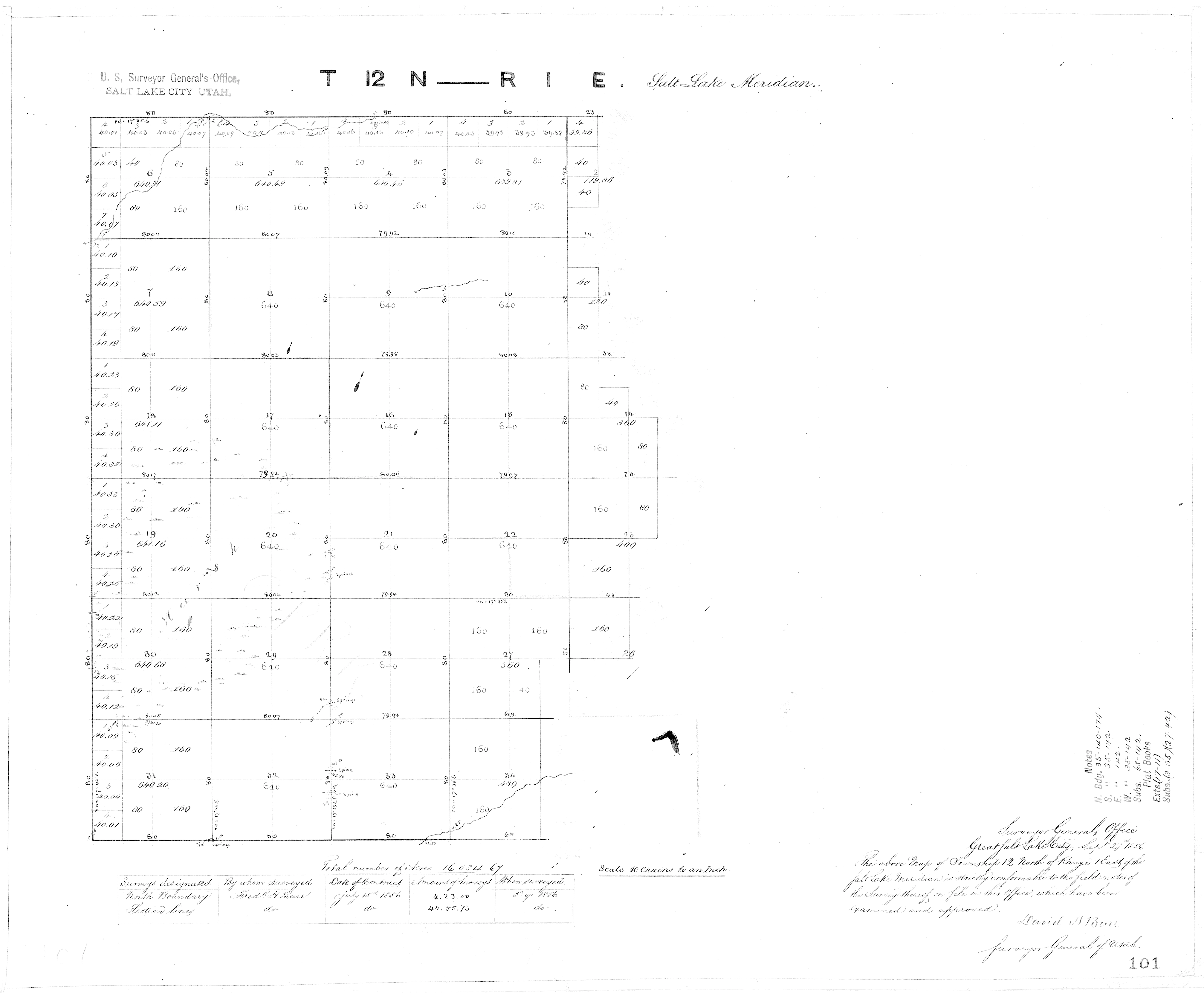
Frederick H. Burr Survey 1856,
Note North Branch of the Logan River in Section 34 (Lower right)
Township 12 North, Range 1 East
Courtesy Cache County GIS
https://bridgerlandaudubon.org/wp-content/uploads/2024/12/UT260120N0010E0-C0101.tif
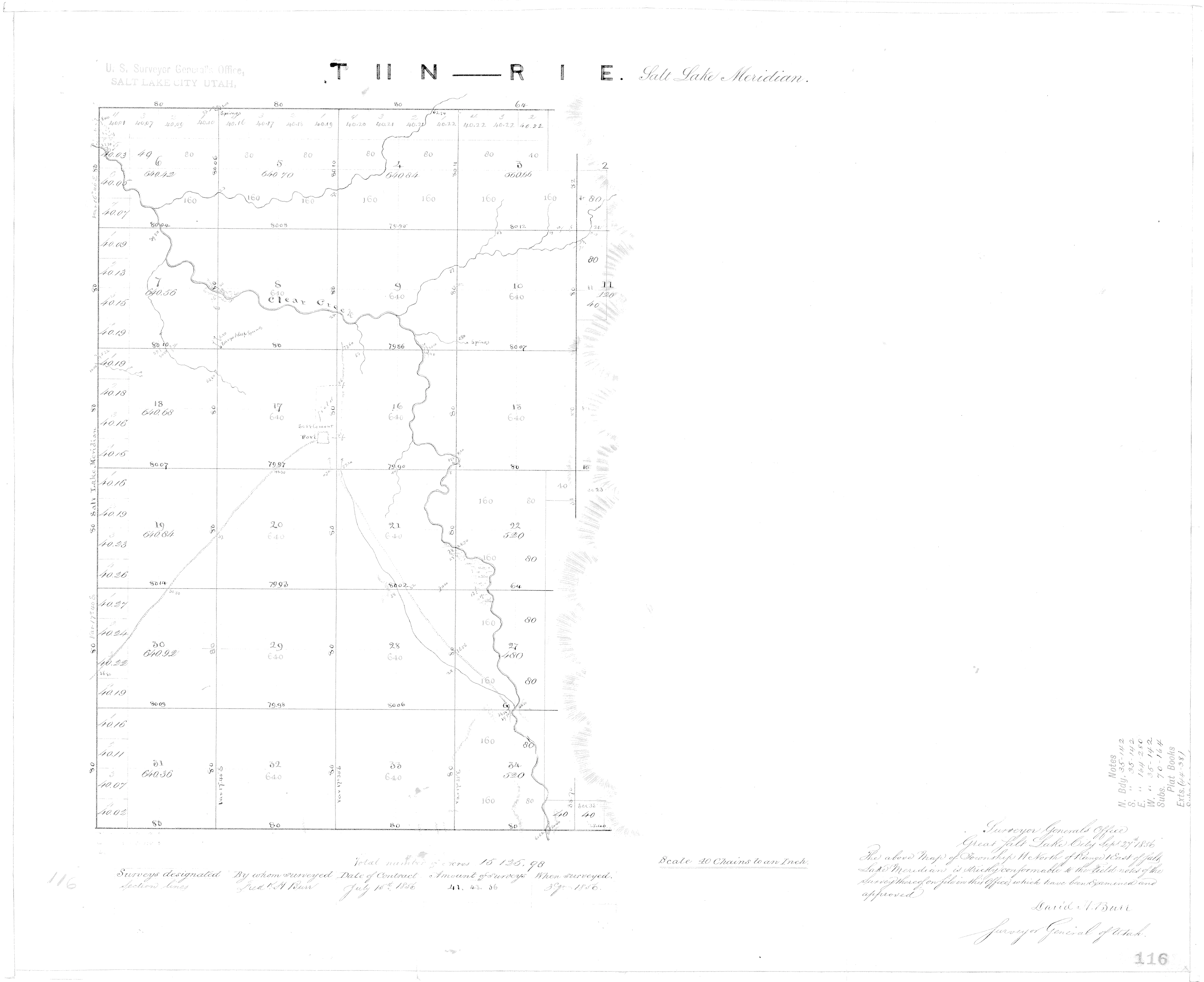
Frederick H. Burr Survey 1856,
Township 11 North, Range 1 East
Courtesy Cache County GIS
https://bridgerlandaudubon.org/wp-content/uploads/2024/12/UT260110N0010E0-C0116.tif
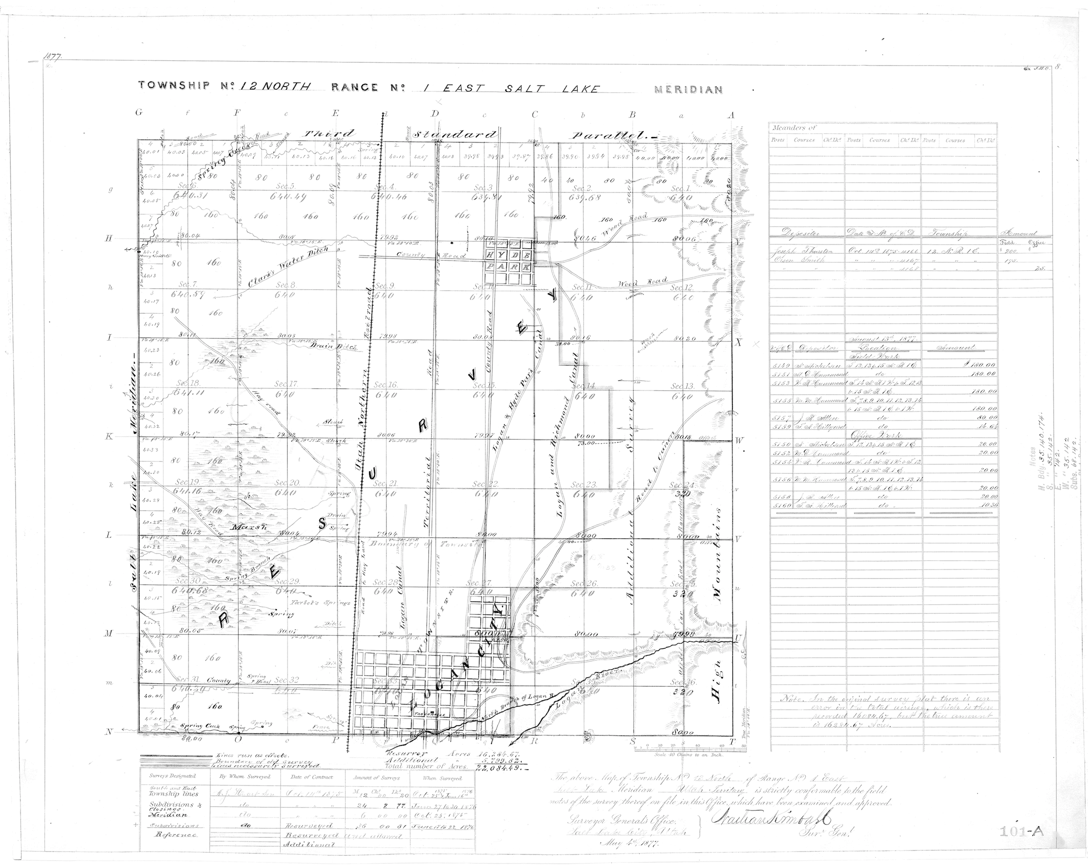
Nathan Kimball Survey, May 4, 1877, Logan City, Logan River Forks into North and South Branches
Note Canals Drawn from the Rivers
Township 12 North, Range 1 East
Courtesy Cache County GIS
https://bridgerlandaudubon.org/wp-content/uploads/2024/12/UT260120N0010E0-C0101A.tif
Logan City Survey Map 1891 (Marked with North & West City Boundaries from November 9, 1923)
https://cms9files.revize.com/loganutlibrary/quickimages/Research%20_Learn/LocalHistory/Maps/Surveyors_map_full.jpg
Logan River Above State Dam, Near Logan, UT – 10109000, USGS, Zoom in on the map over the city. Look for the “Little Logan River.”
https://waterdata.usgs.gov/monitoring-location/10109000/#parameterCode=00065&period=P7D&showMedian=false
Look for six references to the “Little Logan River” in the 1922 Kimball Decree.
1922 Kimball Decree, https://bearrivercommission.org/docs/Kimball%20Decree.pdf
History of Land Surveying in Cache County Storymap https://storymaps.arcgis.com/stories/76d1d5d4c52c44efac0df9df2f3ad07b
Note that River Hollow Park is classified as wetlands along the river (it’s even in the floodplain at least for the Logan River frontage – the Little Logan River does not appear to be part of the floodplain mapping, perhaps because it has been kept closed off since the concrete sides were added to prevent erosion after a big flood in the mid-to-late 1990s. Cutting off the perennial flows was a mistake, and it is a reversible mistake until and unless the natural river channel is lined and obstructed with a pump house in the river channel, which is the current plan.
Updated Wetlands Mapping in Cache County https://ugspub.nr.utah.gov/publications/circular/c-133.pdf
Zoom in to Logan, UT and look for the references to the “Little Logan River.”
U.S. Fish & Wildlife Service Wetlands Inventory: River Hollow Park: Classification: Rp1FO (decode)
Wetland Type: Forested/Shrub Wetland
Acres: 0.30
Image Date(s): xx/16
Project Metadata: click here
https://fwsprimary.wim.usgs.gov/wetlands/apps/wetlands-mapper/
Logan River Water Users Association Canal System, Date Not Listed, Waterrights, Department of Natural Resources, State of Utah, https://waterrights.utah.gov/docImport/0545/05455978.pdf
Map of the Deltas formed in Lake Bonneville by the Logan River, U.S. Geological Survey, ca. 1890, Held in the Utah State University, Merrill-Cazier Library, Special Collections and Archives
https://digital.lib.usu.edu/digital/collection/Bear/id/109/
Notes exchanged between Elaine Wilcox and Cartographer Gerald (Jerry) Hughes. See 1875 Field Note and map references to the North Branch of the Logan River and a map naming the Little Logan River, https://bridgerlandaudubon.org/wp-content/uploads/2024/12/Little-Logan-River_Survey-Info.pdf
Cache County Township Plats, Page 59 of 107, 1880-1899, Cache County Records, Held by the Utah State University, Merrill-Cazier Library, Special Collections and Archives,
https://digital.lib.usu.edu/digital/collection/Bear/id/1981/rec/1
1967 Logan Parcel Map by Lynn N. Harris, Optimized by ImageOptimizer.net, Note the North Branch Logan River and the Logan Hyde Park Canal “Y”
https://bridgerlandaudubon.org/wp-content/uploads/2024/12/1967-Parcel-Map-by-Lynn-N.-Harris-Section34.IMG_9840.png
Cache County Parcel Viewer, Look for references to the “North Branch of Logan River.”
https://gis.cachecounty.gov/Websites/Parcel%20and%20Zoning%20Viewer/
The History of a Valley: Cache Valley Utah-Idaho, Cache Valley Centennial Commission, 1856.
http://www.riversimulator.org/Resources/History/UtahCounties/HistoryOfCacheCounty1996Peterson.pdf
EPA Streams and Waterbodies in Utah
National Hydrography Dataset
Rivers are blue, canals brown. The Little Logan River is blue.
https://19january2021snapshot.epa.gov/sites/static/files/2014-09/documents/utah.pdf
See also 19January2021Snapshot.epa.gov
The North Branch of the Logan River is on the map of the National Park Service Nationwide Rivers Inventory!
About the Nationwide Rivers Inventory
The Nationwide Rivers Inventory (NRI) is a listing of more than 3,200 free-flowing river segments in the United States that are believed to possess one or more “outstandingly remarkable” natural or cultural values judged to be at least regionally significant. Hence, NRI river segments are potential candidates for inclusion in the National Wild and Scenic River System.
NPS Director’s Order #46, Nationwide Rivers Inventory states: “Pursuant to (1) Executive memorandum dated August 2, 1979, and (2) the related Procedures for Interagency Consultation to Avoid or Mitigate Adverse Effects on Rivers in the Nationwide Rivers Inventory promulgated by the Council on Environmental Quality August 11, 1980, 45 Fed. Reg. 59190-59192, all Federal agencies, as part of ongoing planning, management, and environmental review activities, must assess whether rivers on their lands that are identified in the NRI are suitable for inclusion in the NWSRS. Federal agencies, including the NPS, must take care to avoid or mitigate actions that could adversely affect NRI segments, and must consult with the NPS20F 21 prior to taking actions which could effectively foreclose wild, scenic, or recreational river status on NRI rivers.”
The National Park Service Nationwide Rivers Inventory
https://experience.arcgis.com/experience/2b84b8786f5a4dea83c28debbe018be9
Mitigating Flood Risk: Replacing the Crockett Diversion Structure and Restoring the Logan River, Civil & Environmental Engineering, Civil Engineering, Utah State University, 2022, https://engineering.usu.edu/cee/students/senior-projects/fall2021-spring2022/crockett-diversion-structure
Trending today-Daylighting Piped Rivers and Streams:
How ‘Daylighting’ Buried Waterways Is Revitalizing Cities Across America,
Urban centers are exhuming creeks and streams once covered up to control floodwater—and bringing life back in the process, Smithsonian Magazine, America’s Waterways: The Past, Present and Future, Innovation, March 15, 2023, https://www.smithsonianmag.com/innovation/how-daylighting-buried-waterways-is-revitalizing-cities-across-america-180981793/
Hardesty, Bill, Stream Daylighting brings waterways above ground for all to enjoy, The City Journals, Apr 05, 2021 12:13PM, https://www.valleyjournals.com/2021/04/05/352606/stream-daylighting-brings-waterways-above-ground-for-all-to-enjoy
Ron Love, Daylighting Salt Lake’s City Creek: An Urban River Unentombed, 35 Golden Gate U. L. Rev. (2005).
http://digitalcommons.law.ggu.edu/ggulrev/vol35/iss3/4
Logan City Proposed River Setback Changes
Waters of the U.S. are specifically cited in the Logan Land Development Code, but the effort to describe the Little Logan River as a ditch with [Waters of the United States] WOTUS failed to decrease the setback because it also currently includes a greater setback for rivers with a drainage area greater than one mile – hence the proposed amendments recommended by staff, unanimously recommended by the Planning Commission to the Logan City Council, and scheduled for a Workshop on August 5th, and Public Hearing on August 19, 2025. The Little Logan River is first and foremost the historic river upon which the City of Logan was founded – We want to know how and why is it justified to deny the standard river setback?
Below is a [Utah] DWRights acknowledgment that the perennial river is a natural channel and tributary to the Bear River, and the U.S. ARMY CORPS OF ENGINEERS determination done for the Willow Ski Lakes Subdivision (after which the new Logan Critical Lands Overlay, now being amended to decrease riparian setbacks). We have more details on the current Land Development Code and proposed amendments, in which it says this does not affect Willow Ski Lakes Subdivision, but that’s because Logan City is miscategorizing the Little Logan River/Little Logan Canal as a “canal/ditch”.
- Jul 18, 2025 email exchange with Hilary Shughart:
- Hilary asked:
Has the Division of Water Rights made a determination that the lower reach of the Little Logan River is “just a ditch”, as the City of Logan says, despite the fact that it is a perennial springfed river from Willow Park to the confluence?The Army Corps of Engineers did the evaluation for the Willow Ski Lakes Subdivision, and clearly described the natural channel (despite having been relocated and straightened half a century ago).*[1]
The City of Logan says DWR said it’s a ditch and therefore they have to classify it as a ditch with a 15’ setback instead of 25’ for a river. Given the springfed perennial nature, wouldn’t that DWR require the same permit protection as the USACE, which says that no matter whether it is called a canal or a river, the Clean Water Act 404 Permit process applies because it is a tributary to the Bear River?
Thanks.
Hilary
*[1] U.S. Army Corps of Engineers Determined that it is a natural channel at Willow Lakes Subdivision:
“The lower channel extent, including the portion within the study area, is a natural channel feature and is considered an (a)(2) tributary.”
https://www.spk.usace.army.mil/Portals/12/documents/regulatory/jd/2021/2021-07/SPK-2020-00588-AR-ApprvdJDForm-NWPR.pdf - Jul 18, 2025 email response:
- “According to my understanding, this section of the Little Logan River is considered a river by our office.”
B. Skyler Buck, P.E.
Regional Engineer, Northern Region
Utah Department of Natural Resources
Division of Water Rights
Campaigns:
2024-2025 Petition to Save the Little Logan River
Thank you for signing the petition to “Save and Restore the North Branch of the Logan River, a.k.a. the Little Logan River.”
1325 readers responded and made your voices known. Note, the city administration changed, but your voice is still needed.
