Cinnamon Teal Bear River Migratory Bird Refuge 05-11-2020
Courtesy & Copyright Chris Crook
Cache Valley Wild Bird Photo Contest 2021 One of the species that may be seen
Saturday August 23, 2025
Birding with Bridgerland Audubon at the Amalga Barrens.
We met at 7 AM in Logan and caravaned to the Amalga Town Hall where we met up with a few more people. Kim Sullivan had checked out 4 walkie-talkies from USU to have one in each vehicle as we planned to be mostly driving. Meg Kast also helped to co-lead this trip. We had 4 vehicles, 3 with leaders and radios in each. Fifteen people participated in this event.
Because of the excessively dry summer no shorebirds were using this area at the time except for Killdeer. We did also see Horned Larks, a Virginia Rail, Northern Harrier, Savannah Sparrow and Brewer’s Sparrow. Singing Western Meadowlarks was a highlight of the trip. A total of 22 species were found. One benefit of the drought was a shortage of mosquitoes!
Birds, Butterflies & Blooms at Tony Grove,
Saturday August 2nd, 8:30 a.m. Carpool from US Forest Service District Ranger Station, 1500 East Hwy 89
Explore Tony Grove and its abundance of birds, butterflies and wildflowers with Jack Greene
Stokes Nature Center, Bridgerland Audubon and the International Friends Program are sponsoring a field trip to Tony Grove from 8:30-early afternoon Saturday, August 2nd.
“Beautiful flowers with wings”, a phrase frequently used to express the exquisite beauty of butterflies. Join the Bridgerland Audubon Society for a field trip to learn the secret lives of these amazing sparks of life, the flowers they visit, and birds that eat them! Place: Tony Grove meadows.
Meet at the US Forest Service parking lot 1500 East Hwy 89 at 8:30 am on August 2nd for carpooling. Return early afternoon. Bring lunch, water, light jacket, hat or sun screen, binoculars, camera, butterfly net (we will have some).
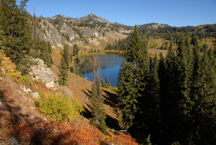
A Tony Grove Meadow Courtesy USDA Forest Service Teresa Prendusi, Photographer
The Tony Grove Recreation Area and the Mount Naomi Wilderness are being inducted into the Old-Growth Forest Network during a ceremony at the backcountry trailhead on Tony Grove Lake Road at 12:00 p.m. on Sunday, July 27th, 2025. This honor will recognize the two areas in Logan Canyon for their beauty and biodiversity. [Rod Boam, Cache Valley Daily]
Mount Naomi Wilderness [from the Uinta Wasatch Cache National Forest, USDA Forest Service]
Specific Area Information
Location: Northern Utah, northeast of Logan, Utah
USGS Quad: Naomi Peak, Tony Grove Peak and Mount Elmer
Difficulty: Moderate to severe with elevations rising to more than 9,900 feet.
Use: Frequent year round, especially on weekends and holidays.
About the Area
With spectacular alpine scenery, Mount Naomi Wilderness lies between the Logan River and the Utah-Idaho state line. It comprises approximately 44,523 acres. At 9,980 feet, Naomi Peak, near the eastern boundary, is the area’s highest point, although this mountainous country contains several other peaks towering above 9,000 feet. On the western side, there are many deep, scenic canyons.
Wildflowers carpet the large mountain meadows during summer blooms, and several flowers are unique to this region. You’ll find large populations of moose, elk, and deer, and beavers that are well established in several streams. The area is often used for hiking, backpacking, horseback riding, snow shoeing, and back country skiing.
Trails meander up the major canyons on the western side of the wilderness from trailheads near U.S. Highway 91. The trails join with others to link the area to U.S. Highway 89. Mount Naomi Wilderness has about 12 system trails totaling approximately 73 miles, including the Mount Naomi National Recreation Trail.
When traveling in the Mt. Naomi Wilderness Area, please adhere to the regulations below:
All campsites must be greater than 200 feet away from water sources, trails and other occupied campsites.
All litter must be carried out. Do not bury anything other than human waste, which should be buried 6″.
Horses may be tethered for no more than 1 hours within 200 feet of any water source.
Horses may not be tied to any tree for more than 1 hour and must be moved sooner if damage is occurring.
All feed and hay taken onto National Forest land must be tagged as “Certified Weed Free” by the county extension agent.
Campfires are prohibited where firewood supply is depleted, when fire building threatens wilderness qualities, or for public safety.
Groups entering the wilderness must be no larger than 10 people. Groups exceeding the size limit must separate into groups of 10 or less and remain at least 1/2 mile apart on trails and while camping.
Dogs are permitted; domestic stock is limited to 14 per party.
Maximum of 14 consecutive nights at an individual site.
For further information, please contact the Logan Ranger District at (435) 755-3620
or the Public Lands Information Center at (801) 466-6411.
Above extracted from: https://www.fs.usda.gov/r04/uinta-wasatch-cache/wilderness
Slopes of Mount Naomi Courtesy Wikimedia, Andrey Zharkikh, Photographer Licensed CC by 2.0